Sites, Maps & Geofences for Equipment Management
Define Your Sites, Locate Your Assets, Control Your Yards with Geofencing
When managing heavy equipment across multiple jobsites, yards, and offices, staying on top of location and boundaries isn’t optional — it’s essential. Part of Tenna’s Asset Tracking and Management, Sites, Maps and Geofences tools give you a single platform to define your sites, draw virtual perimeters, and watch assets move in real-time.
- Capture asset entry to and exit from defined site boundaries.
- Get alerts on equipment moving outside a site or after hours.
- See what assets are still on site after a job wraps up.
Benefits of Tenna’s Geofencing & Live Maps for Sites
Accurate Site Management
Know exactly which owned and rental assets are onsite and maintain current project information so everyone—field, office, accounting—is working from the same data. This streamlines communication between all teams.
Optimize Utilization Across Sites
Easily identify underutilized equipment on site that can be deployed elsewhere. This eliminates billing for unused assets and enables better rental time management and decision making around equipment needed.
Enhanced Asset Tracking
Zoom out for insights on job site activity or in on individual assets. See movement history to identify inefficiencies or available equipment, and know what assets are still onsite after a job ends to reduce closeout delays and costs.
Minimize Equipment Hoarding
Identify and reduce equipment hoarding to better coordinate project needs, allocate resources appropriately and mediate disputes. Plus, reduce labor costs for handling and re-handling assets that a site does not need.
Security & Loss Prevention
Get alerts when assets leave a geofenced area unexpectedly or during unauthorized times to increase response times and reduce the risk of theft, equipment misplacement, or unauthorized use of assets.
Better Costing & Financial Control
Assign assets to sites automatically based on boundary crossings with geofencing. This drives more accurate job costing, rental allocations and costs, expense tracking and record keeping.
More Automated Billing
Save time by automating asset-to-site assignments opposed to manually reconciling billing.
Tenna’s integrations with accounting and ERP systems streamline this data and
keep field and accounting teams in sync.
“Just by using Tenna, noticing missing pieces of equipment, and being able to go back and recover them before the job gets to a point where it’s kind of gone, I would say we’ve seen savings of anywhere from $50,000 to $120,000.”
- Shoring Engineers
Key Features of Sites, Maps & Geofences
Create and maintain detailed records for every area of operation, including project sites, yards, offices and other work zones. Add contact information, site types, owners or managers, addresses, and other relevant data.
With Sites defined, your team gains clarity about where assets belong and which assets are deployed where.
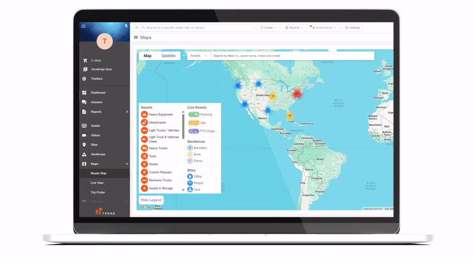
Tenna’s advanced Master Maps let you see all your assets, sites, and geofences together. Use the Live View to pinpoint which pieces of equipment are running, idling, or offline. Filter by asset category, project status, name, and more. Real-time counts show how many assets are at each location. And the Find Nearest tool helps dispatch teams locate the closest available equipment and operators.
Field crews can see instantly where the assets they need or are expecting are, instead of searching and making endless phone calls to locate equipment. Share and navigate with integrated address sharing and directions.
Plus, historical mapping through Trip Finder also helps you understand movement patterns, trip histories, and equipment distributions.
Geofencing empowers you to draw precise virtual borders around your sites, including boundaries, zones and fences, and receive alerts or trigger specified actions when assets cross those lines.
Geofence alerts can be flexibly configured by asset category, time of day, project roles and more to reduce noise and ensure notifications are meaningful. Get alerts for the moments that matter—like when a skid steer leaves a jobsite at 8 pm on a Saturday.
Watch how Tenna’s GPS tracking and geofencing empowers E-Z Construction to access their equipment utilization and job costs more accurately.
Why Choose Tenna’s Approach
Mixed fleets (owned and rented) can be managed together with geofencing
Mobile accessibility so field teams can update site details from anywhere
Tied together with utilization, maintenance, reporting and billing so data is actionable
Ready to get control over your sites?
Learn more about Tenna’s geofencing software.
Frequently Asked Questions
What is a geofence?
A geofence is a virtual boundary defined on a map using GPS (or other location tech). When an asset enters or leaves that boundary, the system can trigger alerts or automate workflows.
How precise are geofences? Can they map to real jobsite boundaries?
Yes. Tenna geofences are sufficiently flexible to match real site perimeters or subdivide large project sites into zones.
Can geofences be used for billing or cost allocation?
Absolutely. A common use is auto-assigning assets to sites when they enter geofenced areas. That lets you generate more accurate job costing or site-based billing, reducing manual work and errors.
Read how equipment data can fuel profitability.
How are alerts configured when assets cross geofence boundaries?
You can set alerts to fire on specific entry or exit events. They can be scoped by asset category, by schedule, and sent to specific people or teams. That way you minimize unnecessary alerts and focus on actionable events.
Will geofencing help reduce construction site theft?
Yes. Geofencing provides strong deterrence and detection and improves reaction and recovery times. When an asset moves outside its designated geofence unexpectedly, you’re notified. That visibility helps recover assets faster and discourage unauthorized removal.
Read more strategies for construction site theft prevention.
How do sites differ from geofences?
Sites in Tenna are logical or physical locations (i.e., projects, yards, offices) with mapped addresses or coordinates. Geofences are virtual boundaries drawn around sites or within sites to monitor or trigger actions based on location events. Sites give you structure; geofences give you automation and control.
Want to See What
Tenna Looks Like?
Book a Demo


